Warning
This section is under development.
Benefit Index#
The Benefit Index expresses the value generated by ocean uses and realized on land. Although activities occur offshore, their benefits typically emerge at coastal hubs — cities, ports, processing centers, or other facilities where economic or social gains materialize. The framework focuses on this point of emergence rather than the full production chain, even when value may later accrue far from the coast.
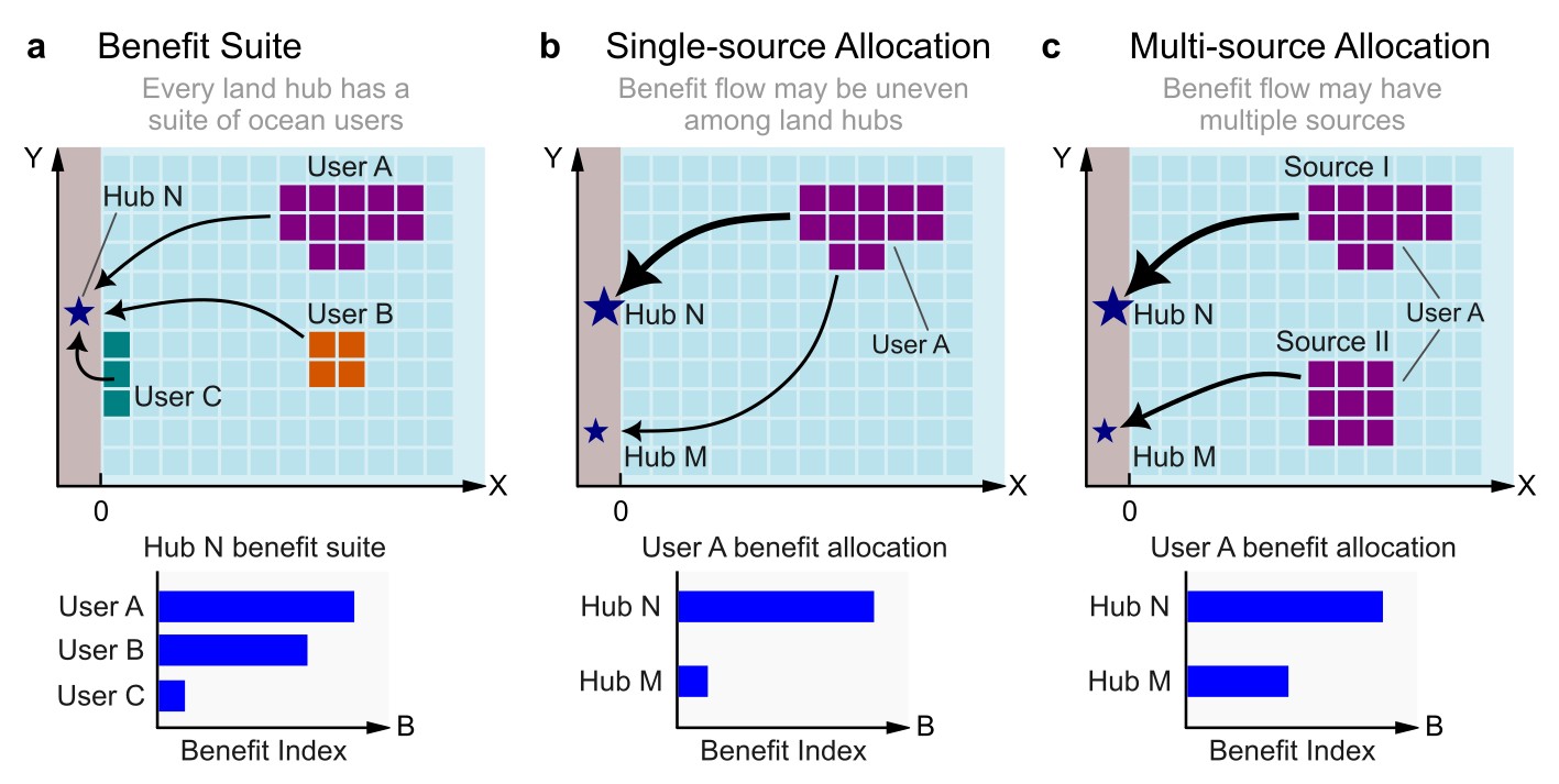
Conceptual elements of the Benefit Index. (a) Benefit suite: a hub receives a total benefit composed of multiple contributions from different users. (b) Single-source allocation: a user contributes benefit to one or more hubs from a single ocean area. (c) Multi-source allocation: a user with multiple spatial source areas distributes benefits to different hubs, creating a more complex benefit-flow structure.#
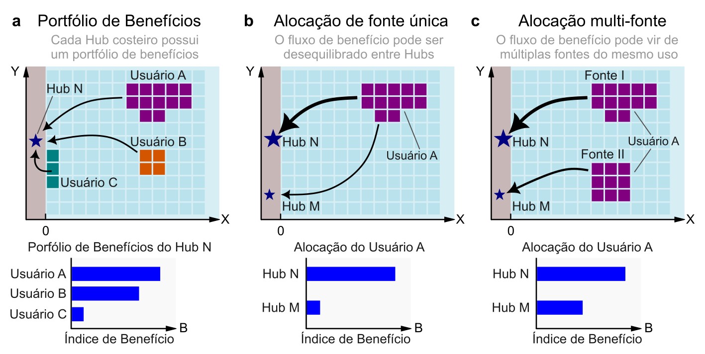
Elementos conceituais do Índice de Benefício. (a) Portfólio de benefícios: um hub recebe um benefício total composto por múltiplas contribuições de diferentes usuários. (b) Alocação de fonte única: um usuário contribui com benefício para um ou mais hubs a partir de uma única área oceânica. (c) Alocação de múltiplas fontes: um usuário com diversas áreas espaciais de origem distribui benefícios para diferentes hubs, formando uma estrutura de fluxo de benefícios mais complexa.#
Users and Hubs#
In the PEM framework, an Ocean User is defined as an economic sector that operates in the ocean and possesses a characteristic set of practices and modes of use. An Ocean User is not an individual company. For example, fisheries as a sector constitute one user, even though many firms participate in it. Likewise, offshore wind energy, tourism, or maritime transport may each represent a distinct user.
Each user aggregates all activities of the sector but may operate across multiple spatial locations. These locations—specific patches or areas in the ocean—are referred to as sources of benefit. A single user may therefore have one or many sources, each contributing differently to the total benefit flow.
Ocean users are linked to Hubs through teleconnections: multiple activities can direct their benefits to a single location. A port, for example, may receive value from fisheries, offshore energy, tourism, and shipping. This set of benefits is referred as the the Hub Benefit Suite.
Benefit Allocation#
Two mechanisms describe how benefits flow from ocean space to hubs:
Single-source allocation. A user has one spatial source (e.g., a single fishing ground) but may distribute its benefits across multiple hubs. Part of the benefit may flow to one port, while the remainder supports another.
Multi-source allocation. A user consists of several spatial sources—such as multiple fishing areas or multiple offshore wind farms—each contributing differently to one or more hubs. This allows benefits to be partitioned according to the spatial origin of the activity.
Benefit Assessment#
The Benefit Index is derived from an economic attribute that quantifies the value that flows from the Ocean Users to the hub — such as jobs, tax revenue, or production measures — depending on available data. Information constrains may also require to define hubs at the level of coastal municipalities.
Mapping the Benefit#
The spatial distribution of benefits in the PEM framework is defined as directly proportional to Ocean Use intensity. Under this assumption, an intensity map of a given Ocean User serves as a close proxy for that user’s spatial benefit. The primary step required to map this dynamic is to transform raw Ocean User data into a continuous, fuzzy intensity map.
Let \(i\) represent an Ocean User and \(j\) represent a specific ocean spatial unit (a grid cell). The local spatial benefit \(B_{i, j}\) is proportional to the local use intensity \(U_{i, j}\):
To transition from proportionality to an absolute value, a scaling constant \(c_i\) is calculated for each user as the ratio of total benefits to total use intensity:
The total benefit for a user, \(\sum_{j} B_{i, j}\), is derived from the benefit assessments conducted at the coastal hubs. Using this scaling constant, the aggregate benefit can be downscaled and mapped across ocean space via a linear transformation:
Where \(B_{i, j}\) represents the spatial expression of benefit, also referred to as the benefit density.
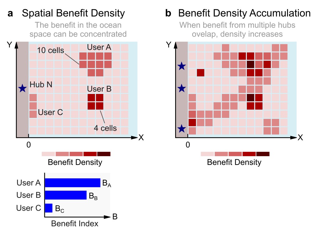
Mapping Benefit back to the ocean. (a) Benefit density concept: each user generates spatially distributed benefits whose intensity depends on how concentrated or diffuse the contributing ocean area is, reflecting differences in spatial efficiency. (b) Hub-specific and cumulative density maps: each hub has its own benefit-density map; overlapping contributions from multiple hubs or users can be summed through map algebra, producing areas of higher cumulative benefit density.#
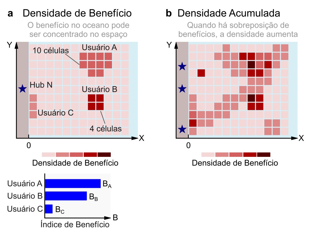
Mapeando o Benefício de volta ao oceano. (a) Conceito de densidade de benefício: cada usuário gera benefícios distribuídos espacialmente, cuja intensidade depende de quão concentrada ou difusa é a área oceânica que os origina, refletindo diferenças de eficiência espacial. (b) Mapas de densidade específicos e cumulativos por hub: cada hub possui seu próprio mapa de densidade de benefício; contribuições sobrepostas de múltiplos hubs ou usuários podem ser somadas por meio de álgebra de mapas, produzindo áreas de maior densidade de benefício cumulativa.#
Ocean User Intensity Maps#
To construct these benefit surfaces, the framework distinguishes between three main typologies of ocean users based on how their spatial data is structured.
Uniform, homogeneous, polygon-based use In multi-source allocations, benefits originate from discrete, clearly bounded geographic zones. These sources are represented as polygons with uniform internal intensity, corresponding to formal operational boundaries. Examples include offshore oil and gas fields, wind farms, aquaculture concessions, or marine protected areas. Each polygon acts as an independent source asset, allowing benefits to be neatly partitioned by spatial origin and aggregated consistently across hubs.
Kernel-density expression Some single-source activities emit benefits from fixed localized points or linear infrastructure, but influence the surrounding marine environment in a gradual, probabilistic, and distance-dependent manner. For these sectors, use intensity is modeled using a Kernel Density Estimation (KDE) approach to create continuous heatmaps.
Intensity is highest at the source focal points (e.g., coastal cities, ports, or tourism gateways) and decays smoothly as distance offshore increases. This method is ideal for sectors like coastal recreation and artisanal tourism, where value generation is anchored to a coastal hub but diffuses fluidly across open water without rigid boundaries.
Intensity surface expression Other single-source activities are not tied to a specific point of origin on the coast, but instead manifest as an aggregate footprint across open ocean space. These activities are captured as continuous intensity surfaces derived directly from observational or modeled data. Examples include industrial fishing effort (e.g., VMS tracking), shipping lane density, or recurrent vessel traffic. Unlike kernel density models, these surfaces reflect the direct, recorded footprint of the activity within the marine domain, rather than proximity to an onshore infrastructure node.
Together, these three spatial typologies ensure that economic benefits are mapped in ways that mirror the true operational realities of diverse maritime sectors, keeping them fully compatible with hub-based tracking and cumulative spatial planning tools.